Montezuma Castle is 104 minutes up Interstate 17 from downtown Phoenix, and 106 minutes back. Add them up and you have three and a half hours in the car for a cliff dwelling most people see in under an hour. That arithmetic is the whole trick of day trips from Phoenix. Arizona is big, the good stuff is spread out, and a destination that looks close on a map can eat an entire day once you count the drive home. This guide counts it for you, both ways, and says plainly when a trip is really an overnight.
Short answer: The best day trips from Phoenix are the Superstition Mountains, under an hour east; Tucson’s west side, about two hours south; and Jerome with Montezuma Castle on the way, about two and a quarter hours north. From May to September add Flagstaff, where the normal July high is 82.0°F instead of Phoenix’s 106.5°F. Anything more than about three hours each way, including Tombstone, Bisbee and the Grand Canyon, is an overnight trip, not a day trip.
Prices, hours and road conditions in this guide were last checked on September 24, 2026. Drive times are off-peak estimates from downtown Phoenix, out and back; add time for traffic leaving the Valley and for weekend crowds on I-17.
Day trips from Phoenix at a glance
This table covers every destination within about two and a half hours that isn’t Sedona or the Grand Canyon, which have their own guides. The minutes are one way; double them for the time you’ll actually spend driving.
| Destination | Direction; drive each way | Elevation | Cost (checked Sept 2026) | Best months | Verdict |
|---|---|---|---|---|---|
| Superstition Mountains: Lost Dutchman, Goldfield | East; 54-56 min | About 2,000 ft | $10-$20 per vehicle at Lost Dutchman | November-April | Best short trip |
| Casa Grande Ruins National Monument | South; 67 min | 1,423 ft | Free | November-March | Pair with Picacho Peak |
| Boyce Thompson Arboretum | East; 75 min | 2,470 ft | $24.95 adults; $16 in summer | October-April | A morning, not a day |
| Tortilla Flat | East; 75 min | 1,745 ft | Free to drive | October-April | The road beyond is closed to through traffic |
| Arcosanti | North; 74-76 min | 3,758 ft | Not published; ask the operator | Any | For architecture fans |
| Wickenburg | Northwest; 79-80 min | 2,055 ft | Free to wander | November-April | Half-day western town |
| Picacho Peak State Park | South; 85-86 min | 1,944 ft | State park day-use fee | February-March | A stop on the way to Tucson |
| Montezuma Castle National Monument | North; 104-106 min | 3,251 ft | $10 adults, good 7 days, includes Tuzigoot | Any | An hour’s stop; pair with Jerome |
| Payson and Tonto Natural Bridge | Northeast; 106-135 min | 4,600-4,900 ft | $10 adults at the bridge | April-October | Summer escape |
| Globe and Tonto National Monument | East; 116-140 min | 2,800-3,500 ft | $10 for the cliff dwelling (16+) | October-April | Long day for history fans |
| Prescott | North; 119-121 min | 5,354 ft | Free to wander | April-October | Best cool-air town |
| Tucson’s west side | South; 122-135 min | 2,365-2,900 ft | $25 per car at Saguaro; $29.95 Desert Museum | October-April | Best full day |
| Jerome | North; 133-135 min | 5,070 ft | Free to wander | Any; midweek | Best small town |
| Biosphere 2 | South; 143-144 min | 3,852 ft | Not published; ask the operator | October-April | Only if science is the point |
| Flagstaff and Lowell Observatory | North; 155-159 min | 6,900-7,232 ft | Free town; observatory ticketed | May-October | The longest true day trip |
How far can you go on a day trip from Phoenix?
Use one rule: if the drive is longer than two and a half hours each way, it isn’t a day trip. At that point you are spending five hours in the car, leaving the Valley at dawn to beat the traffic and coming home in the dark, and the destination gets whatever’s left of the middle of the day. Most of what the internet sells as Phoenix day trips breaks that rule. The Grand Canyon’s South Rim is 255 minutes each way by our routing, Tombstone 208, Bisbee 238. Those are wonderful places, and they deserve a night.
Direction matters too, because the Valley’s traffic doesn’t. Northbound I-17 on a Friday afternoon and southbound on a Sunday afternoon fill with Phoenicians heading to and from the high country, and the stretch of I-10 between Phoenix and Tucson carries a lot of trucks. Leave early, come back early and the off-peak times in this guide are realistic. Leave at 10 a.m. on a Saturday and they aren’t.
If you have half a day
Stay within about 80 minutes. The Superstition Mountains are the obvious choice: Lost Dutchman State Park is 56 minutes east of downtown and Goldfield Ghost Town 54, so you can hike or wander in the morning and be back for lunch. Casa Grande Ruins National Monument, 67 minutes south, takes an hour to see and costs nothing. Boyce Thompson Arboretum, 75 minutes east near Superior, fills a cool-season morning. Wickenburg, 79 minutes northwest, gives you a small western downtown and a museum. Closer still, the town of Cave Creek is 48 minutes north, at the Valley’s desert edge, for a slow lunch and a walk.
If you have a full day
You can go up to about two and a quarter hours each way and still have five or six hours on the ground. Tucson, 122 minutes south, is the richest option. Jerome, 133 minutes north, pairs naturally with Montezuma Castle on the way up. Prescott, 119 minutes northwest, is the easiest cool-weather town. Payson and Tonto Natural Bridge, 106 and 134 minutes northeast, make a summer escape to the Mogollon Rim. And Globe with Tonto National Monument makes a long history loop to the east.
If you have a long day and don’t mind the driving
Flagstaff is 155 minutes north, Lowell Observatory 159, and both sit near 7,000 feet, which makes them the best summer day trip in the state if you can face five hours in the car. The Verde Canyon Railroad in Clarkdale, 126 minutes away, is its own long day once you add the train ride. Biosphere 2, 144 minutes south near Oracle, is a long way to go for one site unless you pair it with Tucson.
The best day trips from Phoenix by interest
If you’d rather choose by what you like than by the clock, here is the short list for each interest, with the one-way drive from downtown.
History and archaeology. Casa Grande Ruins, 67 minutes south and free, is the quickest. Montezuma Castle, 104 minutes north, and Tuzigoot, near Clarkdale, share one $10 ticket (2026 price) and are the best preserved. Tonto National Monument, 140 minutes east, is the one where you can walk up to a cliff dwelling rather than look at it from below. For Spanish colonial history, Mission San Xavier del Bac is 135 minutes south.
Small towns. Jerome, 133 minutes, for the views and galleries. Prescott, 119 minutes, for a courthouse square and cool air. Wickenburg, 79 minutes, for western history. Cave Creek, 48 minutes, for a slow lunch at the Valley’s edge.
Desert scenery. The Superstitions, 54 to 56 minutes east, and Saguaro National Park’s western district, 132 minutes south, are the two big ones. Picacho Peak, 85 minutes, is worth the stop in a wet spring.
Forest, water and cooler air. Tonto Natural Bridge, 134 minutes, and the pines around Payson; Flagstaff, 155 minutes, for the full mountain climate. The lakes and the Salt River have their own guide.
Science, stars and gardens. Lowell Observatory, 159 minutes, where Pluto was discovered, and Biosphere 2, 144 minutes. For plants, Boyce Thompson Arboretum, 75 minutes, and the Arizona-Sonora Desert Museum, 134 minutes.
With kids. Goldfield Ghost Town’s little railroad and mine tour, 54 minutes; the Desert Museum’s animals, 134 minutes; and Lowell’s telescopes, 159 minutes. With small children, keep the drive under about 90 minutes each way and plan a stop in the middle; the Superstitions and Goldfield make an easy morning, and nobody has to sit still for two hours to get there.
Which day trips escape the summer heat?
Elevation is the only thing that beats a Phoenix summer, and the gains are dramatic. Downtown Phoenix sits at 1,087 feet. Every thousand feet you climb takes a few degrees off the afternoon, and the high country north and east of the Valley starts at around 5,000 feet. Tucson doesn’t help much: it is 1,300 feet higher than Phoenix, but its normal June high is still 101.2°F.
| Place (NOAA 1991-2020 normals) | Elevation | Normal July high | Normal January low | Snow |
|---|---|---|---|---|
| Phoenix (Sky Harbor) | 1,087 ft downtown | 106.5°F | 46.0°F | Almost never |
| Tucson | 2,365 ft downtown | 100.2°F | 40.8°F | Rare |
| Prescott | 5,354 ft downtown | 90.3°F | 26.2°F | Some winters |
| Flagstaff | 6,900 ft downtown | 82.0°F | 17.6°F | About 90 inches a year |
So the summer rule is simple: go north or up. Flagstaff is the full escape, 24.5 degrees cooler than Phoenix on a normal July afternoon. Prescott takes 16 degrees off and is 36 minutes closer. Payson and the Rim country, at around 4,900 feet, sit in between. Jerome, at 5,070 feet, sits well above the Verde Valley and feels cooler for it.
Winter reverses the logic. Flagstaff averages about 90 inches of snow a year, with close to 21 inches in January alone, and its normal January low is 17.6°F. Prescott’s is 26.2°F. A winter storm on the Mogollon Rim can turn I-17 north of Camp Verde into a slow, icy crawl, so from November to April check the forecast and the road conditions before you head north, and pick a desert destination such as the Superstitions, Tucson or Casa Grande on a stormy weekend. The Valley itself almost never sees snow; the mountains you can see from it often do.
The best day trips from Phoenix, one by one
Each entry gives the drive out and back, the elevation, what to do, what it costs and when to go, then an honest verdict. They run roughly from closest to farthest.
Superstition Mountains: Lost Dutchman State Park and Goldfield
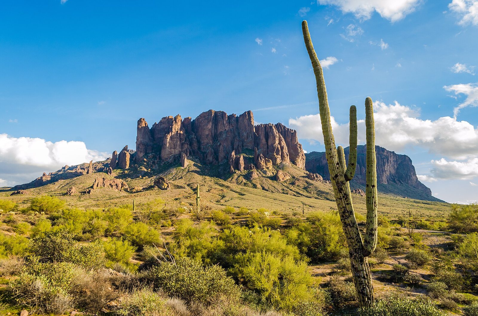
East, 54 to 56 minutes each way. About 2,000 feet. The Superstitions are the jagged wall you can see from the East Valley, and they are the easiest real mountain day from Phoenix. Lost Dutchman State Park sits at their base, “only 40 miles east of Phoenix” in the park’s own words, and charges $10 per vehicle with one person, $20 with two to four and $5 for a walk-in or cyclist (checked September 2026). Its trails run from easy desert loops to the steep Siphon Draw climb; our hiking guides cover the routes in detail.
Next door, Goldfield Ghost Town is a rebuilt 1890s mining camp with shops, a narrow-gauge railroad and a mine tour. The railroad and mine tour cost $12 each for adults, $10 for seniors and $8 for ages 5-12, the zipline $15, and shops and tours run from 10 a.m. to 5 p.m. daily (checked September 2026). It is touristy and knows it; kids tend to love it.
The lakes up the road are a separate story. Canyon Lake is closed this fall while Salt River Project draws it down about 54 feet for roughly 16 weeks from September 16, 2026, and Saguaro Lake is a separate drive to the north; our guide to lakes near Phoenix covers them both. Verdict: the best half-day trip from Phoenix from November to April. In summer, go at dawn or not at all, because the trails here have little shade and sit only about 1,000 feet above downtown Phoenix.
Cave Creek and Carefree
North, 48-49 minutes each way. About 2,100 feet. Cave Creek is a western-flavored town at the Valley’s northern desert edge, with saloons, steakhouses and shops strung along Cave Creek Road, and neighboring Carefree adds a small town center and the Carefree Desert Gardens, 49 minutes from downtown Phoenix. Just north of Cave Creek, Spur Cross Ranch Conservation Area has easy trails along one of the few desert streams near Phoenix that sometimes runs with water. Verdict: less a day trip than a long, pleasant lunch with a walk attached, and the easiest way to feel you’ve left the city without committing to a highway. From May to September, go for dinner rather than lunch.
Tortilla Flat and the Apache Trail
East, 75 minutes each way. 1,745 feet. State Route 88, the Apache Trail, climbs from Apache Junction past Goldfield, Lost Dutchman and Canyon Lake to Tortilla Flat, an old stagecoach stop that is now a single street with a restaurant, a saloon and a general store. The paved drive to Tortilla Flat is scenic, twisty and free, and it is the part of the famous route you can still drive in an ordinary car.
Beyond Tortilla Flat the road turns to gravel and then stops being a through route. SR 88 has been closed to through traffic between Fish Creek Hill and Apache Lake since flood damage in 2019, and the part the state reopened in 2024 is open only to high-clearance four-wheel-drive vehicles. The old loop to Roosevelt Lake and back through Globe is therefore not a day trip anyone should plan in a rental car. Verdict: worth it as a short scenic drive combined with the Superstitions; not worth it as an attempt at the full Apache Trail.
Boyce Thompson Arboretum
East, 75 minutes each way, just west of Superior. 2,470 feet. This is a botanical garden of desert plants from around the world, laid out along trails below the cliffs of Picket Post Mountain, with a creek, a small lake and big shade trees in places the Valley doesn’t have them. It is a lovely, quiet morning, and it’s the easiest nature day for anyone who doesn’t want to hike uphill.
Check the schedule before you go. On September 24, 2026, the arboretum was on its summer hours, open 6 a.m. to noon Wednesday through Monday and closed on Tuesdays, with adult admission at $24.95 and a $16 summer price. Verdict: a very good half day from October through April, and a dawn-only outing in summer. Superior’s small downtown and the drive east on US 60 through Queen Creek Tunnel make a pleasant add-on, and Globe is 40 minutes farther.
Casa Grande Ruins National Monument and Picacho Peak
South, 67 minutes to the ruins and 85-86 minutes to Picacho Peak. 1,423 to 1,944 feet. Casa Grande Ruins, in Coolidge, protects a four-story adobe “Great House” built by the Hohokam in the 1300s, now standing under a large protective roof. It is free to enter, small enough to see in an hour and one of the few places near Phoenix where you can stand beside a Hohokam building rather than a wall of petroglyphs or a museum case.
Picacho Peak State Park, farther south along I-10, is the knob of rock every Tucson-bound driver stares at. The park is open 5 a.m. to 8 p.m. year-round and its trails from sunrise to sunset (checked September 2026). In a wet spring, the lower slopes can fill with wildflowers, usually in February and March, and the peak was the site of a small Civil War skirmish in 1862. Its summit trail is steep and uses cables in places; treat it as a serious hike, not a stroll. Verdict: both work as stops on the way to Tucson, or as a short cool-season loop on their own. In summer, both are too hot after mid-morning to enjoy.
Tucson’s west side: Saguaro National Park, the Desert Museum and San Xavier
South, 122 minutes to downtown Tucson and 132 to 137 minutes to the sights. 2,365 to 2,900 feet. Tucson is Arizona’s second city and the best full day trip from Phoenix, as long as you accept that you’ll see one side of it. The west side is the one to choose. Saguaro National Park’s western district protects some of the densest saguaro forest in the Sonoran Desert, and entry is $25 per private vehicle, valid for 7 days (checked September 2026). Next to it, the Arizona-Sonora Desert Museum is part zoo, part botanical garden, part natural history museum, and mostly outdoors; its hours page lists a 7:30 a.m. opening and general admission at $29.95 (checked September 2026).
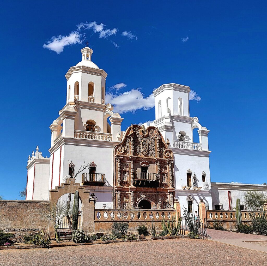
Then cross to Mission San Xavier del Bac, south of the city, the white mission church completed in 1797 on the Tohono O’odham Nation, which still serves as an active parish; visitors can go inside to see its painted and carved interior. That gives you a full, sensible day: park at dawn, museum through the late morning, mission in the afternoon, and dinner in Tucson, which UNESCO named the first U.S. City of Gastronomy in 2015, before the two-hour drive home.
Save the east side for another trip. Sabino Canyon is 137 minutes from downtown Phoenix, and the national park’s eastern district is on the far side of Tucson from the west-side sights. Verdict: the best full day trip from Phoenix from October to April. In summer, Tucson is only slightly cooler than Phoenix, with a normal June high of 101.2°F, so the same dawn-only rules apply.
Biosphere 2
South, 143-144 minutes each way, near Oracle. 3,852 feet. The glass-and-steel science station where a crew sealed itself inside for two years in the early 1990s is now a University of Arizona research facility with public tours. It is genuinely interesting and genuinely far: nearly five hours of round-trip driving for a visit of a couple of hours. Verdict: go if the science is the point of your trip, or fold it into a Tucson overnight, since it’s about 45 minutes north of the city. As a stand-alone day trip from Phoenix, it isn’t worth the drive for most people.
Wickenburg
Northwest, 79-80 minutes each way. 2,055 feet. Wickenburg is a gold-rush town on the Hassayampa River that has leaned into its western past, with guest ranches around it, a compact historic downtown and the Desert Caballeros Western Museum. The drive out on US 60 crosses open Sonoran desert, and it’s the easiest escape from the Valley’s sprawl to the west. Verdict: a pleasant half day from November to April and a good lunch stop on the way to Prescott, but not a destination to build a vacation day around. In summer, it is as hot as Phoenix.
Arcosanti
North, 74-76 minutes each way, just off I-17 at Cordes Junction. 3,758 feet. Architect Paolo Soleri began building Arcosanti in 1970 as a prototype of what he called an “arcology”, a dense town designed to use as little land and energy as possible. Half a century later it is a small, unfinished concrete village on the edge of a canyon, known for its bronze wind bells, which are cast on site. Guided tours are the way to see it; check the price before you go. Verdict: fascinating for anyone who cares about architecture and a strange, quick detour for everyone else. It works best as a stop on the way to Jerome or Prescott rather than as the whole day.
Montezuma Castle National Monument
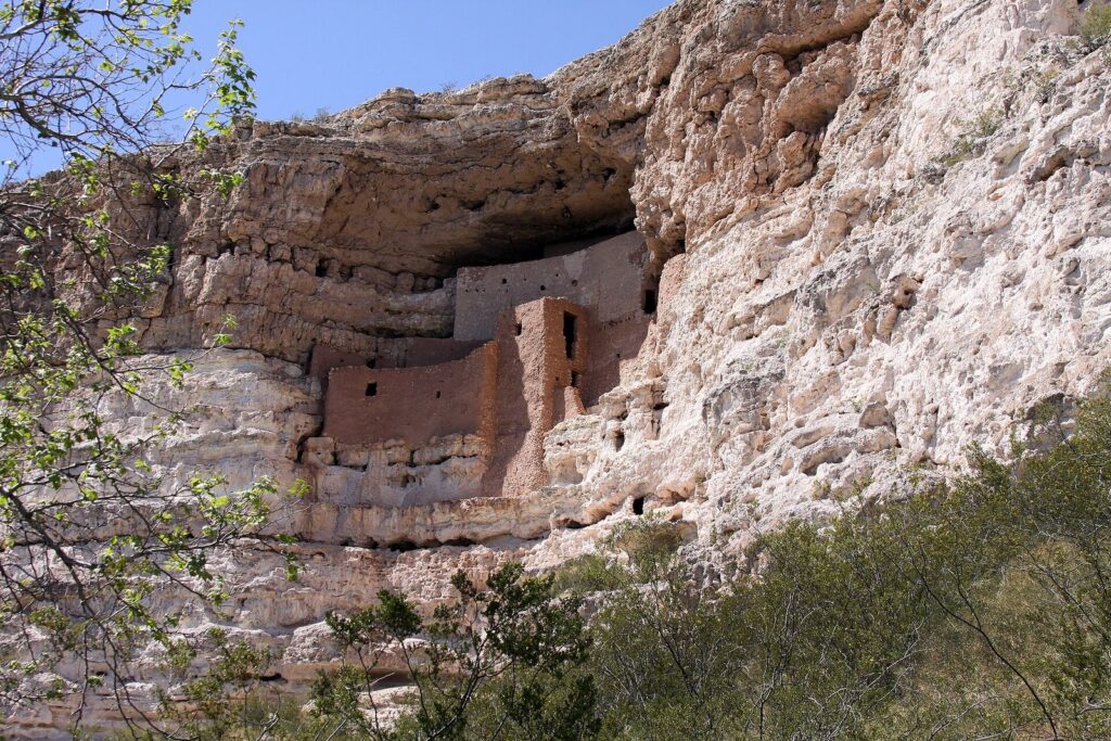
North, 104-106 minutes each way, near Camp Verde. 3,251 feet. The “castle” is a five-story, 20-room cliff dwelling built by the Sinagua people into a limestone cliff above Beaver Creek, and it is one of the best-preserved in the country. You see it from a short, paved, shaded loop at the foot of the cliff; nobody goes inside. Entry is $10 per adult, children 15 and under free, and the ticket covers Tuzigoot National Monument near Clarkdale for 7 days. Montezuma Well, a separate unit farther up the valley with a spring-fed sinkhole and more ruins, is free (checked September 2026).
Verdict: absolutely worth an hour, and absolutely not worth three and a half hours of driving on its own. Treat it as the first stop on a Jerome day, or as a stop on the way to Sedona.
Jerome, Tuzigoot and the Verde Canyon Railroad
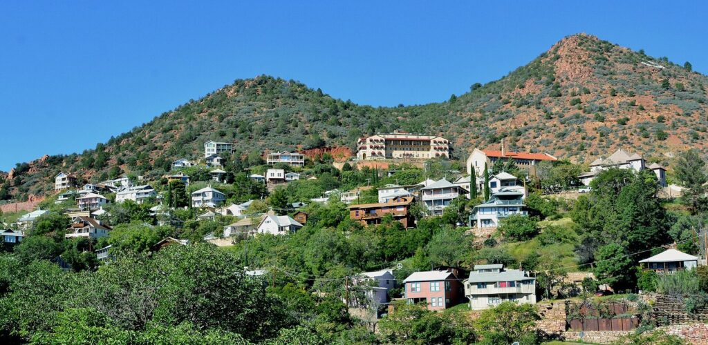
North, 133-135 minutes each way. 5,070 feet. Jerome is a former copper-mining camp stacked on the side of Cleopatra Hill, once billed as the “Billion Dollar Copper Camp” and now home to a few hundred people, galleries, tasting rooms and cafes. The streets are steep, the views across the Verde Valley to the red rocks of Sedona are enormous, and the whole town is walkable in a morning. Jerome State Historic Park, in the 1916 Douglas Mansion above town, tells the mining story and is open 9 a.m. to 4:30 p.m. daily (checked September 2026).
Build the day around it. Stop at Montezuma Castle on the way up, see Jerome from late morning through lunch, then drop down to Tuzigoot National Monument, a hilltop pueblo near Clarkdale that your Montezuma Castle ticket already covers. Clarkdale is also home to the Verde Canyon Railroad, 126-128 minutes from Phoenix, whose slow round trip through the canyon is a whole long day on its own and needs booking ahead.
Parking is the catch. Jerome’s streets are narrow, the lots are small and weekends fill both. Verdict: the best small-town day trip from Phoenix, in any season, and best midweek. At 5,070 feet it is noticeably cooler than the Valley in summer, and it can see snow in winter.
Prescott
North, 119-121 minutes each way. 5,354 feet. Prescott was Arizona’s first territorial capital, and it still feels like a courthouse town. The Yavapai County Courthouse sits on a shaded plaza of lawns and elms, and Whiskey Row’s saloons and restaurants line Montezuma Street across from it. Around town, the Granite Dells’ rounded boulders and Watson Lake make an easy outdoor add-on.
The reason to come is the air. Prescott’s normal July high is 90.3°F, 16 degrees below Phoenix’s, and its summer evenings on the plaza are the cheapest air conditioning in Arizona. Its normal January low is 26.2°F, so winter visits need a coat. Verdict: the best cool-weather town within two hours and the easiest summer escape from Phoenix. Pair it with Jerome for a long loop through the mountains, or with Wickenburg on the way back in the cool season.
Payson and Tonto Natural Bridge State Park
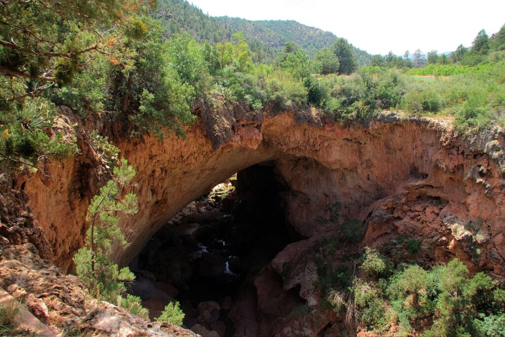
Northeast, 106-107 minutes to Payson and 134-135 minutes to the bridge. 4,600 to 4,900 feet. Payson sits in the pines below the Mogollon Rim, the 200-mile escarpment that marks the edge of the Colorado Plateau, and it is where much of Phoenix goes on summer weekends. Its big draw for visitors is Tonto Natural Bridge, believed to be the largest natural travertine bridge in the world, which you can view from lookouts on top or climb down to on short, steep trails. The state park charges $10 for adults 14 and older and $5 for ages 7-13, opens at 9 a.m. and takes its last entry at 4 p.m. (checked September 2026).
Verdict: a very good summer day, when the Valley is at its worst and the Rim country is nearly 4,000 feet higher. Leave early, because the Beeline Highway (State Route 87) fills with weekend traffic, and in winter check for snow on the Rim before you go.
Globe and Tonto National Monument
East, 116 minutes to Globe and 140 minutes to Tonto National Monument. 2,800 to 3,500 feet. Globe is a copper town with a historic downtown, and beyond it State Route 188 runs north to Tonto National Monument, where two Salado cliff dwellings look out over Roosevelt Lake. The Lower Cliff Dwelling Trail is a mile round trip and takes about an hour; the Upper Cliff Dwelling is a 3-mile, three-to-four-hour round trip. The monument charges $10 for visitors 16 and older hiking to the dwellings, and it warns that the trail can close for extreme heat, lightning, bee activity or flooding. It is closed on Thanksgiving, Christmas and New Year’s Day (checked September 2026).
Because the Apache Trail is closed to through traffic, this is an out-and-back drive via US 60 through Superior, which is also how you reach Boyce Thompson Arboretum. Verdict: a long, rewarding day for history lovers from October to April, and a poor summer choice; the monument’s trail is exposed and closes in extreme heat.
Flagstaff and Lowell Observatory
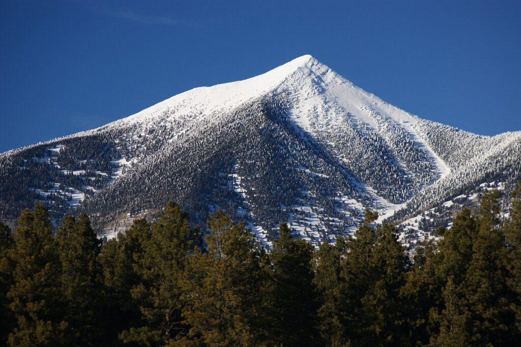
North, 155 minutes to downtown and 159 to Lowell Observatory. 6,900 to 7,232 feet. Flagstaff is a mountain college town at the foot of the San Francisco Peaks, with a walkable downtown on old Route 66, Northern Arizona University and a completely different climate. Its normal July high is 82.0°F. On Mars Hill above downtown, Lowell Observatory, where Pluto was discovered in 1930, sells general admission that covers guided tours, more than 150 exhibits, the historic buildings, theater shows and evening stargazing, and it’s good all day if you leave and come back (checked September 2026). Reservations aren’t needed for general admission.
Verdict: the longest real day trip from Phoenix and the best summer one, if five-plus hours in the car doesn’t bother you. Stay for the observatory’s evening program and you’ll drive home in the dark, which is a strong argument for a night in town. From November to April, Flagstaff is a snow town, with about 90 inches a year, so check the forecast and road conditions on I-17 before you commit.
How do you plan a day trip from Phoenix?
When should you leave?
Early, in every season. In summer, leave by 6 a.m. so you arrive before the heat and before the weekend traffic heading north builds. In winter, the limit is daylight. In mid-December the sun rises at 7:25 a.m. and sets at 5:22 p.m., so a 155-minute drive to Flagstaff each way leaves you less than five hours of light on the ground, even if you leave at sunrise. In mid-March, with sunrise at 6:40 a.m. and sunset at 6:35 p.m., the same trip leaves you nearly seven. Try to be home before dark: the highways out of the Valley narrow to two lanes in places, and night driving after a long day is where trips go wrong.
Is a federal park pass worth it?
The federal sites on this list charge by the person or by the car: $10 per adult at Montezuma Castle, which also covers Tuzigoot; $10 for each visitor 16 and older hiking to Tonto National Monument’s cliff dwellings; and $25 per vehicle at Saguaro National Park, while Casa Grande Ruins is free (all checked September 2026). Two adults doing Montezuma Castle, Tonto and Saguaro would pay $65. Four adults would pay $105, and that’s where the $80 interagency annual pass listed on Tonto’s fee page starts to pay for itself, since at per-person sites it covers the pass holder plus three more adults. If a Grand Canyon trip is also in your plans, the pass becomes an easy yes.
What should you pack for a day out of the Valley?
Pack for two climates. A summer day that starts at 106°F in Phoenix can end in the 50s after dark in Flagstaff, whose normal July low is 51.4°F, and a winter trip north can meet snow. Carry more water than you expect to drink, fill the tank before you leave the Valley on the longer eastern and northern routes, and download offline maps, because cell service can be patchy in the canyons along US 60, SR 87 and SR 88.
Which trips are not day trips?
These are the destinations that show up on almost every list of Phoenix day trips and shouldn’t. The times are off-peak drives from downtown Phoenix, one way, measured in September 2026.
- The Grand Canyon’s South Rim: 255 minutes each way. That is eight and a half hours of driving for a few hours at the rim. It has its own guide, and it deserves a night in or near the park.
- Tombstone: 208 minutes each way. Almost seven hours round trip for a few blocks of Old West reenactment. Combine it with Bisbee, 238 minutes away, and Kartchner Caverns, 181, on an overnight trip to southeastern Arizona.
- Petrified Forest National Park: 264 minutes each way. Pair it with a night in Holbrook or Flagstaff.
- Lake Havasu City: 223 minutes each way. A weekend destination, not a day out.
- Williams: 182 minutes each way. It’s the Grand Canyon Railway town, which means it belongs to a Grand Canyon trip.
If southeastern Arizona tempts you, make it an overnight and do it properly. Kartchner Caverns State Park, a living limestone cave shown on reserved guided tours, is 181 minutes from Phoenix at 4,606 feet. Tombstone is 208 minutes away at 4,546 feet, and Bisbee, a former copper town stacked on steep hillsides at 5,524 feet, is 238. Base yourself in Bisbee or nearby Sierra Vista for a night and the three fit comfortably into two days, with the high-desert climate as a bonus: all three sit more than 3,000 feet above Phoenix.
Sedona is the exception in the other direction. At 135 minutes each way it works as a day trip, and it gets its own guide because there is too much to cover here. If you do go, Montezuma Castle is a short detour off I-17 on the way up.
What to skip on a day trip from Phoenix
- Skip the Grand Canyon as a day trip. Eight and a half hours of driving for a few hours at the rim is a bad trade. Book a night.
- Skip trying to drive the full Apache Trail loop. SR 88 is closed to through traffic between Fish Creek Hill and Apache Lake, and the reopened section is for high-clearance four-wheel-drive vehicles only. Drive to Tortilla Flat and turn around.
- Skip Canyon Lake this fall. It’s closed for the SRP drawdown that began September 16, 2026, and runs about 16 weeks.
- Skip Montezuma Castle as a stand-alone trip. It’s a superb hour and a poor day. Pair it with Jerome or Sedona.
- Skip Biosphere 2 unless the science is the point. Nearly five hours of driving for one site; fold it into a Tucson overnight instead.
- Skip desert destinations at midday from May to September. The Superstitions, Picacho Peak, Casa Grande and Tucson are all as hot as Phoenix or nearly so. Go north and up instead.
- Skip heading north on a winter storm day. Flagstaff averages about 90 inches of snow a year, and I-17 over the Rim can slow to a crawl. Pick a desert destination that weekend.
Frequently Asked Questions
What is the best day trip from Phoenix?
For a full day, Tucson’s west side: Saguaro National Park, the Arizona-Sonora Desert Museum and Mission San Xavier, about two hours south. For a small town, Jerome, about two and a quarter hours north, with Montezuma Castle on the way. For a half day, the Superstition Mountains and Lost Dutchman State Park, under an hour east.
How far is Tucson from Phoenix?
About 114 miles, or roughly two hours by car from downtown Phoenix to downtown Tucson off-peak (checked September 2026). The west-side sights, including Saguaro National Park and the Desert Museum, take 132 to 135 minutes. Traffic leaving the Valley and trucks on I-10 can add a lot, so leave early and plan to come back before dark.
Can you do the Grand Canyon as a day trip from Phoenix?
You can, but you shouldn’t. The South Rim is about 228 miles and 255 minutes each way from downtown Phoenix by our routing, which means eight and a half hours in the car for a few hours at the rim. Stay at least one night in the park, in Tusayan or in Flagstaff, and the trip becomes worth the drive.
What are the best day trips from Phoenix in summer?
Go north and up. Flagstaff, at 6,900 feet, has a normal July high of 82.0°F against Phoenix’s 106.5°F. Prescott, at 5,354 feet, averages 90.3°F in July and is two hours away. Payson and Tonto Natural Bridge, at around 4,600 to 4,900 feet, sit in the pines below the Mogollon Rim. Desert destinations such as Tucson and the Superstitions are as hot as Phoenix in summer.
What small towns near Phoenix are worth visiting?
Jerome, a hillside former copper camp two and a quarter hours north, is the best. Prescott, two hours north, is a courthouse-square town with Whiskey Row and cool summers. Wickenburg, 80 minutes northwest, is a western town with a good museum, and Cave Creek, 48 minutes north, is the closest for a slow lunch. Tortilla Flat is barely a town, but the drive there is scenic.
Is the Apache Trail open?
Only in part. State Route 88 is paved and open from Apache Junction past Lost Dutchman and Canyon Lake to Tortilla Flat. Beyond that it has been closed to through traffic between Fish Creek Hill and Apache Lake since 2019 flood damage, and the stretch reopened in 2024 is for high-clearance four-wheel-drive vehicles only. Canyon Lake itself is closed for a drawdown in fall 2026.
Does Flagstaff get snow?
Yes, a lot of it. Flagstaff averages about 90 inches of snow a year, most of it from November through March, with close to 21 inches in January alone, and its normal January low is 17.6°F. From Phoenix, that means checking the forecast and road conditions on I-17 before any winter trip north, and carrying warm layers even if it’s 70°F when you leave the Valley.
Related Phoenix Guides
- Lakes and Rivers Near Phoenix: Saguaro, Canyon and Pleasant lakes, the Salt River and what’s open this season.
Sources and verification
This guide is built from research, not hosted visits. Prices, hours and road conditions were checked on September 24, 2026, against the agencies and operators below. Drive times are off-peak estimates from OSRM routing on OpenStreetMap data, measured from downtown Phoenix in both directions on September 24, 2026; elevations come from the U.S. Geological Survey’s elevation service and climate figures from NOAA’s 1991-2020 normals.
- National Park Service: Montezuma Castle and Tuzigoot fees; Saguaro National Park fees; Tonto National Monument fees and hours and trails; Casa Grande Ruins fees; Grand Canyon directions
- Arizona State Parks: Lost Dutchman; Tonto Natural Bridge; Picacho Peak; Jerome State Historic Park
- Operators: Boyce Thompson Arboretum; Arizona-Sonora Desert Museum; Lowell Observatory; Goldfield Ghost Town
- Salt River Project: Canyon Lake drawdown fact sheet
- Climate and terrain: NOAA 1991-2020 normals for Phoenix, Tucson, Prescott and Flagstaff; USGS Elevation Point Query Service
Photo Credits
- Mission San Xavier del Bac: photo by Cullen328, Wikimedia Commons (CC BY-SA 4.0)
- Montezuma Castle National Monument: photo by Tomas Castelazo, Wikimedia Commons (CC BY-SA 3.0)
- Jerome, Arizona: photo by Mike McBey, Wikimedia Commons (CC BY 2.0)
- Tonto Natural Bridge: photo by ksblack99, Wikimedia Commons (public domain)
- San Francisco Peaks in snow: photo by Martin Ely, Wikimedia Commons (CC BY 2.0)
- Superstition Mountains (featured image): photo by lydia_pirate, Wikimedia Commons (CC BY-SA 4.0)